Math / Earth
Why maps lie
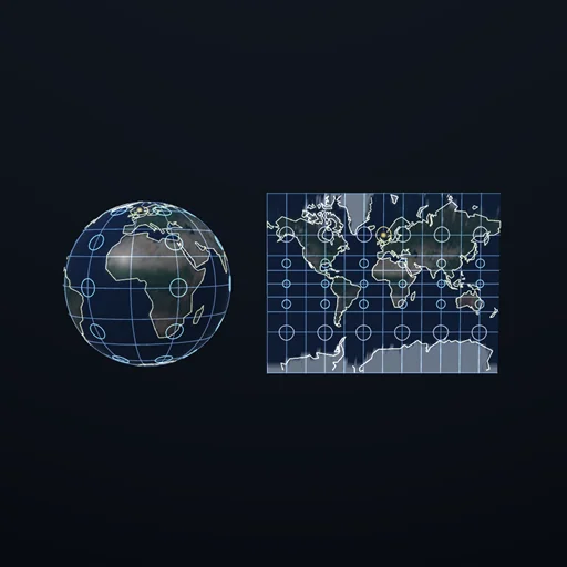
Small circles drawn on the globe, and the same circles on the map: Tissot's indicatrix, which is the whole measurement. Mercator keeps every circle round and swells them past thirty times; Lambert keeps the areas and squashes the shapes; nothing keeps both, and that is Gauss. Greenland is fourteen times smaller than Africa and Mercator draws it 10.47 times too big.
What happens
A sphere cannot be flattened. Not "is hard to flatten" - cannot, and Gauss proved it in 1827: curvature survives bending, so a surface with curvature 1/R² cannot become one with curvature zero without stretching. Every projection therefore chooses which lie to tell, and this module shows the choice being made. On the globe there is a grid of small circles, all the same size, because on the sphere they are. On the map the same circles are projected, and they are not the same size any more: those are Tissot's indicatrices. Their two semi-axes are the scale factors h along the meridian and k along the parallel, and everything follows. A projection is CONFORMAL when h = k everywhere, so every indicatrix stays a circle and shapes survive; it is EQUAL-AREA when h·k = 1 everywhere, so every indicatrix has the same area whatever its shape. Measured across the sphere: Mercator holds the shape factor at exactly 1 and lets the area factor run to 33; Lambert holds the area factor at exactly 1 and pays the same 33 in shape; the equirectangular map holds neither, which is why it belongs on a data grid rather than a wall. No projection holds both - and that is the theorem, not a shortcoming of the four offered here. The famous consequence: Greenland is 2.166 million km² and Africa 30.37, a ratio of fourteen. Mercator's area factor is sec²(latitude), which at Greenland's 72 degrees is 10.47 and at Africa's equator is 1, so on the paper they stand at 1.34 instead of 14. And Mercator has no pole at all - y grows without bound, so every printed Mercator is cut off somewhere; web maps cut at 85.051129 degrees, where y is exactly π and the map comes out square.
Equations used in the module
Equations
Tissot:  a small circle on the globe becomes an ellipse with semi-axes h (along the meridian) and k (along the parallel)
conformal:  h = k everywhere — every indicatrix stays a CIRCLE, shapes survive, areas do not
equal-area:  h·k = 1 everywhere — every indicatrix has the same AREA, shapes do not survive
Theorema Egregium (Gauss, 1827):  curvature survives bending, so no projection can have both
equirectangular:  x = λ, y = φ;  h = 1, k = sec φ;  area 1 … 5.759, shape 1 … 5.759 — holds NEITHER
Mercator:  x = λ, y = ln tan(π/4 + φ/2);  h = k = sec φ;  shape exactly 1, area 1 … 33.163
Lambert cylindrical:  x = λ, y = sin φ;  h = cos φ, k = sec φ;  area exactly 1, shape 1 … 33.163
stereographic:  h = k = 2/(1 + sin φ);  conformal, and the area runs to 17 331 at the far pole
Greenland:  2.166 million km² against Africa's 30.37 — a true ratio of 14.021;  sec²(72°) = 10.472 against sec²(1°) = 1.000, so the drawn ratio is 1.339
Mercator's pole:  y → ∞;  at 89.9° y = 7.044 R and the area factor is 328 281;  web maps cut at 85.051129°, where y = π exactly